
How the monsoon comes: the science of India's rains
About three-quarters of India's yearly rain falls between June and September. Here is how the south-west monsoon forms, the dates it reaches each region, and why it is stronger in some years than others.
Rohit Tandon · 28 October 2026 · 4 min read
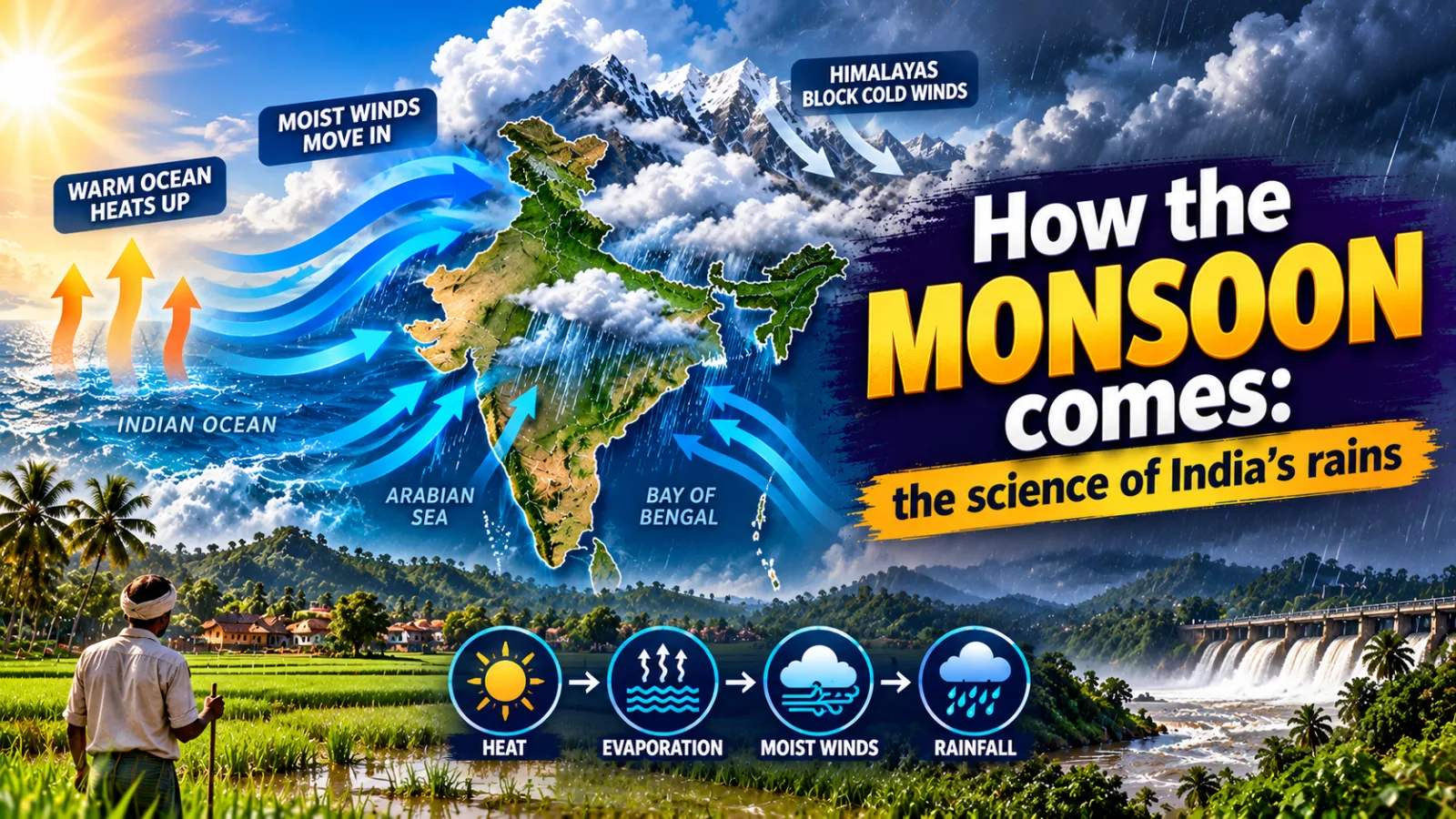
मानसून कैसे आता है, or how does the monsoon come? In summer the land of India heats up much faster than the sea, so moist winds from the Indian Ocean are pulled towards the land, and as they rise over hills and plains they cool and pour down as rain. About three-quarters of India's yearly rainfall comes from this south-west monsoon between June and September.
What does the word "monsoon" mean?
The word comes from the Arabic "mausim", meaning season. Arab sailors noticed long ago that the winds over the Indian Ocean change direction twice a year: from the sea towards the land in summer, and from the land towards the sea in winter. They timed their trading voyages to India by these seasonal winds.
So a monsoon is, first of all, a wind that reverses with the seasons. The rain is what that wind brings. You can read about the waters these winds cross in our page on the five oceans of the world and their facts.
How does the monsoon form?
Think of a tawa on the gas next to a bowl of water. The tawa heats up in minutes, while the water stays cool for a long time. In the same way, in May and June the plains of north-west India and the Tibetan plateau become very hot, the air over them rises, and a zone of low pressure forms there.
Air always moves from high pressure to low pressure. So moist air from over the cooler Indian Ocean flows north towards India. As the Earth spins, these winds bend and reach India from the south-west, which is why we call this the south-west monsoon. When the wet air is pushed up over the Western Ghats or the hills of the north-east, it cools, its water vapour turns into droplets, and heavy rain begins.
The two branches
The monsoon splits into two arms when it reaches India. The Arabian Sea branch strikes the west coast and the Western Ghats, while the Bay of Bengal branch moves into the north-east and then turns west along the Himalayas into the Ganga plains. The two arms meet over north India, which is why Delhi gets its rain later than Kerala or Kolkata.
When does the monsoon reach different places?
The India Meteorological Department (IMD) keeps "normal dates" based on many years of records. The actual date can be a week early or late in any year. The table shows the normal pattern.
| Stage | Place | Normal date |
|---|---|---|
| Onset | Kerala | 1 June |
| Arrival | Mumbai | 11 June |
| Arrival | Delhi | 27 June |
| Covers the whole country | All of India | 8 July |
| Withdrawal begins | North-west India | 17 September |
| Withdrawal complete | All of India | 15 October |
For farmers, the onset over Kerala is the big news of the year. Paddy, cotton and soybean, the kharif crops, are sown once the first good rains soak the soil. The same rains fill village ponds and wells, refill reservoirs and swell rivers, which you can follow in our page on the longest rivers of India, the Ganga, the Brahmaputra and the Indus.
Why does rain fall more in some places than others?
Hills decide a lot. Mumbai, on the side of the Western Ghats facing the sea, gets very heavy rain, while Pune, just behind the hills, is much drier because the winds have already dropped most of their water. This drier side is called a rain shadow, and you can notice it on a train ride from Mumbai to Pune as green slopes give way to drier land.
In the north-east, the moist winds from the Bay of Bengal are trapped by the funnel-shaped Khasi Hills. That is why Mawsynram and Cherrapunji in Meghalaya are among the wettest places on Earth. The same rains feed spectacular falls, listed in our page on the major waterfalls of India.
Did you know? Tamil Nadu gets much of its yearly rain not in July but from October to December, from the north-east monsoon, when the winds reverse and blow from the land and the Bay of Bengal towards the south-east coast.
Why is the monsoon weak in some years?
The monsoon is linked to the oceans far away. In an El Niño year, the Pacific Ocean near South America becomes warmer than usual, and this often weakens India's monsoon winds. A positive Indian Ocean Dipole, when the western Indian Ocean is warmer than the eastern part, can help the monsoon instead.
The IMD measures each season against the Long Period Average, which is about 87 cm of rain for the whole country from June to September. A season with 96% to 104% of this is called "normal". A weak monsoon raises vegetable prices in city markets and worries farmers who depend on rain-fed fields, so the forecast is watched closely in every home.
Key points
- The monsoon is a seasonal wind; the name comes from the Arabic "mausim".
- Hot land and a cooler sea pull moist ocean winds towards India in summer.
- The normal onset over Kerala is 1 June, and the monsoon covers India by 8 July.
- The Arabian Sea and Bay of Bengal branches meet over north India.
- El Niño often weakens the monsoon; the Long Period Average is about 87 cm.
Frequently asked questions
When does the monsoon reach Kerala?
The normal date of onset over Kerala is 1 June. In any given year it can come about a week earlier or later.
What is the difference between the south-west and the north-east monsoon?
The south-west monsoon blows from the sea towards land in June to September and brings rain to most of India. The north-east monsoon blows in the opposite direction from October to December and mainly wets Tamil Nadu and nearby areas.
What is a rain shadow area?
It is the dry side of a mountain range, away from the wind. The hills make the wind drop its rain on the facing side, so places like Pune behind the Western Ghats get much less rain. Read more in our geography articles.
Sources: India Meteorological Department and Encyclopaedia Britannica: Monsoon.
Sources
Found this useful? Share it.